
Historic Details
Words and pictures kindly provided by local residents
Over Whitacre is a rural parish in North Warwickshire. The River Bourne runs through the parish and it is bounded by the parishes of Ansley, Arley, Fillongley, Nether Whitacre and Shustoke. Over Whitacre was part of the Forest of Arden and therefore small areas of land (leys or greens) were gradually cleared to form separate farms rather than nucleated villages as in the Feldon of South Warwickshire. In 1086, when the Domesday Survey was compiled, ½ hide in “Witacre” was held by Hugh de Grandmesnil, and ½ hide was held by the Count of Meulan. By 1203 it was held by Simon de Whitacre whose two sons gave their names to Nether or Ralph’s Whitacre and Over or Jordan’s Whitacre. By the 17th century the parish had two manors: the Sadler family had Holt Hall and the Miller family had land opposite the church near the site of Quarry House. In 1711, Richard Sadler married Ann Miller and their son, Miller Sadler, lived at Over Whitacre House. His nephew Revd Robert Sadler who died in 1831, was the last of the Sadler family to live in the parish. The Weston family who had been iron founders from the 17th Century eventually became the chief landowners. Joseph Weston Swinnerton Weston died in 1957.
The church of St Leonard was built before 1203 and like others in the area gave tithes to the Priory of Markyate near St Albans. Rev’d Thomas Bray who founded the “Society for the Propagation of Christian Knowledge” was the incumbent Over Whitacre in the 17th Century. He established libraries in America and in England and the small stone building which forms part of the Village Hall was used for this purpose as well as a school. The church was rebuilt in 1766 possibly at the instigation of Susanna Miller who held the manorial rights but lived at Mancetter Manor. The original cupola was replaced with the present spier in 1850. The hamlet of Furnace End had a mill, known as “Pulbagge Mill” and another Mill stood near Hoar Hall. Furnace End is associated with the Weston family who lived at Hoar Hall and also the Jennens family of Nether Whitacre and Gopsall in Leicestershire.
Daw Mill colliery originally started out as an airshaft and became the largest deep-mine colliery in Europe. It closed in 2013. The parish has outcrops of sandstone from which many local buildings are built. The economy is still agricultural but many residents work elsewhere.
-Cllr Rita Poulson and Cllr Phil Mason, May 2025
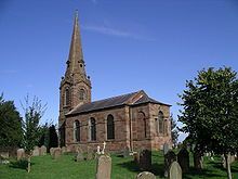
St Leonard's Church, Over Whitacre.
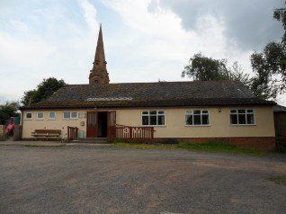
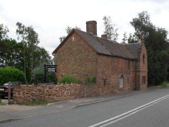
Over Whitacre Village Hall - formerly a School house, built in Tudor Gothic style. c.1840 Grade 11 Listed. Parish Council Meetings are held there each month. Residents of the Parish are always welcome to attend the Meetings. Richard Hancocks
THE PARISH HALL
The Parish Hall is available to hire for events, meetings, clubs, sports and nearly anything else you can thinks of. It has a main hall with a wooden floor large enough for badminton, a carpeted side room large enough for clubs, a catering size kitchen with a serving counter/bar, multiple toilets, ample free car parking, yard area and fenced field.
Bookings are through johnfurnaceend@gmail.com
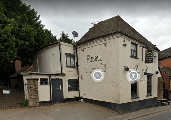
The Bull's Head pub established 1542. Pictured during a period of renaming. Chris Jones
Link to page about it. https://www.facebook.com/pages/The-Bulls-Head-Furnace-End/1104370512981867
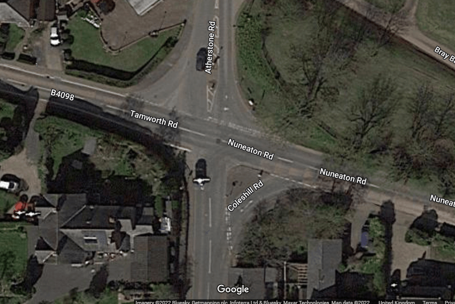
The Furnace End cross roads. Be careful!
Tollgate Cottage (Turnpike Cottage) Monwode Lea, Over Whitacre is a Grade 11 Listed building (Strawberry Hill Gothic Style) c.1769. Richard Hancocks
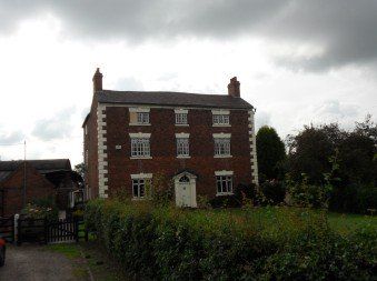
Monwode Lea Farmouse Grade 11 Listed. Richard Hancocks
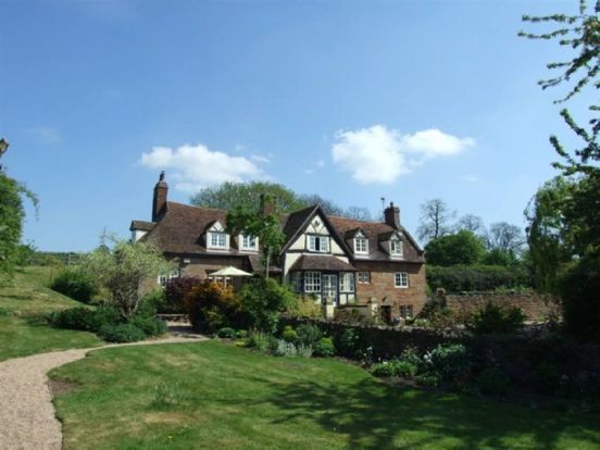
'The Bothie' Over Whitacre, is a fine example of a late 15th century Grade II listed detached country property with barn and bothie ( 'bothie' was a term originally used many years ago for basic accommodation, usually for gardeners or other workers on an estate). Richard Hancocks
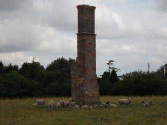
Grade 11 Listed Chimney Remains 200 Metres South of Monwode Lea Farmhouse, Over Whitacre. All that remains of a former farmhouse. Richard Hancocks
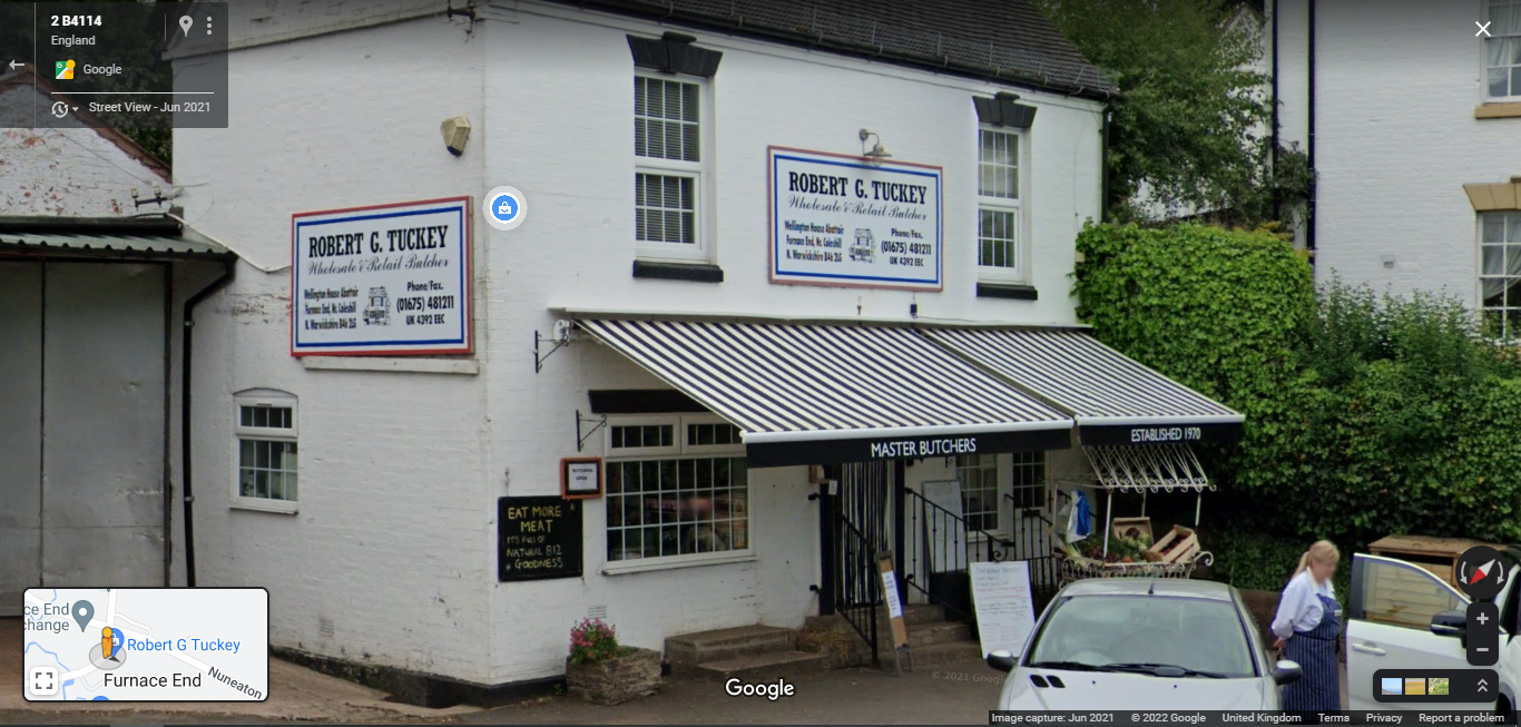
Master Butcher with abbatoir on site. Established 1970. The only place to buy groceries in the village. Chris Jones
Pounds were essential adjuncts to the open fields that were unenclosed, with the growing crops prone to considerable damage by straying livestock. All the animals were the responsibility of their owners and were only released from the pound on payment of a fine. The feudal office of Pinder or Pound-Keeper was a necessary but unpopular one, which was often subject to abuse and occasional assault. Most medieval pounds were small fenced or hedged enclosures, though later brick or stone pounds such as the one in Over Whitacre were often constructed on the sites of former medieval ones. The Pound at Over Whitacre would have formed an integral part of the administration of the local affairs adjacent to the Heyne Field, the Moor Field and the Little Hill Field, and grazing would have been shared among all the members of the parish. A Manor Court, comprising a jury of twelve tenants, presided over by the Lord of the Manor, would have been held twice a year to ensure that good farming practice was observed, and that law and order was maintained. A member of the parish held the office of Pinder, or Pounder and it was his duty to drive straying stock out of the open fields and impound them here in the village pound, until claimed by their owners and the appropriate penalty paid.
Evidence of the Parish Pound in Over Whitacre survives in the name of the lane on which it is situated viz. Pound Lane. It is indicated on current maps which locate its exact position but at present it is not apparent. The Parish Pound has arranged for the pound walls to be rebuilt using sandstone and where it had been covered over by debris from a builder’s yard it is now standing proudly and is tended by the local residents. Local residents concur that they recall its existence, and it was acknowledged as being the remnant of the ancient field system which is known to have existed in the 17th century and before. It is marked on the 6” O.S. map of 1922 and the more recent O. S. 4 cm to 1 km Pathfinder Map No. 914 and the Explorer map for Nuneaton and Tamworth No. 232 Grid Reference 245918.
Part of the rebuilding process required excavations by members of the Hinckley and District Archaeological Society and a local contractor in order to establish the dimensions of the pound. Findings established the size of the earlier Pound and stone foundations were extant under the debris. The dimensions are approximately 6 m x 3 m with three sides of stone, and one part- gated side facing the road.
The pound of Over Whitacre is one of the vestiges of our rural roots and the Open Field system which existed before enclosure. We are fortunate to have documentary evidence for the organisation and management of the parish system of Over Whitacre which survives. A map of Holt Hall estate of 1686 refers to the strip lynchets which existed at that time in the three open fields viz. The Hayne Field, The Moor Field and The Little Hill Field. This map which was commissioned by William Sadler and surveyed by Robert Hewitt a local cartographer of Ansley. Dr. Colin Hayfield and Dr. Andrew Watkins produced an article for Landscape History using this material in November 2012. Also in the Warwick County Record Office, “The Town Book” of 1666-1703 DR(B) 12/15 survives which relates to the charities and overseers of the parish. The Tithe map for Over Whitacre of 1842 (CR 328-32) shows that alongside the Open Fields are Orchard Piece, (near Botts Green Lane) two enclosures called Pinfold Piece, and another called Pinfold Close, all of which are adjacent to the site of the Pound. Although parts of the Open Fields of Over Whitacre had been enclosed by the time the Act of 1819 was passed, 130 acres are mentioned in the Act which were subsequently enclosed. (HL/PO/PB/1/1819/59G3n121)
It is hoped the Pound could be included in Local History Study units for the National Curriculum, Key Stage 2. By learning about the landscape, children would understand its economic, geographic and historical significance. To this effect it is intended to provide information boards near the Pound site in order to help the understanding of its significance in an agrarian economy when most of the community would have been self-sufficient. The heritage of Over Whitacre has been under reported in the past and it is hoped that this project will raise the profile of the rural parish enabling greater understanding of its origins in a farming economy. The oldest building in the parish was removed as part of the mining at Daw Mill and thanks to the skill and generosity of Brian Teall, a member of the Coleshill Civic Society, it was removed from Peggs Hill and preserved for posterity. As the Coleshill and District Civic Society includes Over Whitacre, we hope that the committee will look favourably on the Parish Council’s request for funding to support this project in celebration of the Queen’s forthcoming Jubilee as the Atherstone Civic Society did for Bently Pound to commemorate the Millenium.
Rita Poulson, November 2021, updated by Chris Jones, November 2024
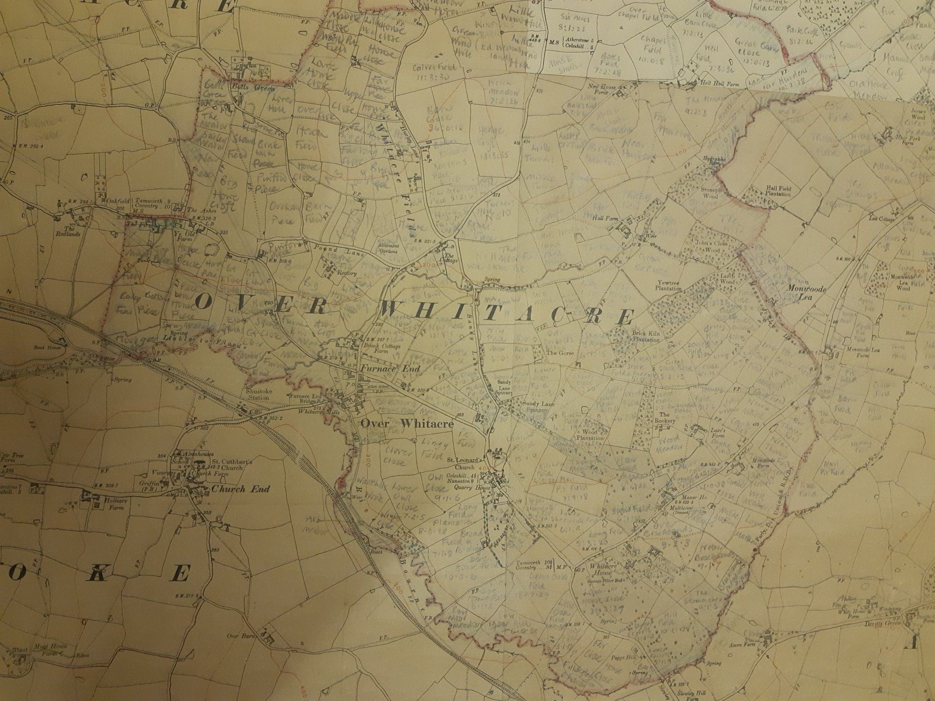
The historic field names researched by Rita Poulson
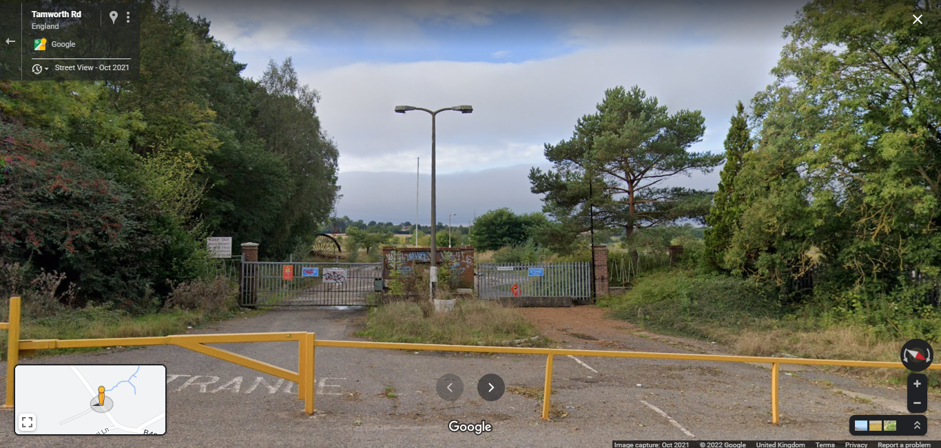
Former Green Valley, used as a coal mine and soon to be restored to it's original green valley. Chris Jones
Bird watching walking path along the River Bourne. Chris Jones
